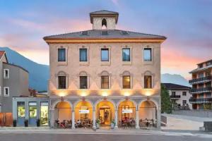
Bellinzona
Street view


Reviews
Share your experiences, help others make the right choice!
Think about what you would like to know if you were looking for a review about a place to relax. Please describe in detail what you liked and what you didn't. What would you advise to other guests and to the hotel owner. The more fully you tell about the hotel, the easier it will be for other people to make a choice and they will be very grateful to you!
Map
Tourist attractions
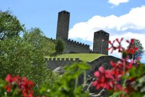
Castelgrande (5 min)
Castelgrande is a historic fortress museum offering insights into Bellinzona’s medieval defense and architecture.
Montebello Castle (11 min)
Montebello Castle museum features medieval artifacts and panoramic views, open March to November.
Villa dei Cedri (13 min)
Villa dei Cedri hosts diverse art exhibitions featuring modern and contemporary works in Bellinzona.
Sasso Corbaro Castle (1.1 km)
Sasso Corbaro Castle museum presents historical exhibits in a well-preserved medieval fortress.
Museum of Memory (1.4 km)
Museum of Memory in Bellinzona displays exhibits related to historical events and collective memory.
MACT/CACT Contemporary Art Ticino (1.7 km)
MACT/CACT showcases contemporary art from Ticino region artists in Bellinzona.