Shirak Province
Description
Shirak , is a province (marz) of Armenia. It is located in the north-west of the country, bordering Turkey in the west and Georgia in the north. Its capital and largest city is Gyumri. It is as much semi-desert as it is mountain meadow or high alpine. In the south, the high steppes crash into mountain terrain, verdant green in the spring, hues of reddish brown in the summer. The province is served by the Shirak International Airport of Gyumri.
Etymology
Part of a series on ArmeniaՀայաստան Culture
- Art
- Cinema
- Music
- Media
- Sport
- Vardavar
- Aragatsotn
- Ararat
- Armavir
- Gegharkunik
- Kotayk
- Lori
- Shirak
- Syunik
- Tavush
- Vayots Dzor
- Yerevan (city with special status)
- v
- t
- e
Shirak Province is named after the Shirak canton of the historic Ayrarat province of Ancient Armenia, ruled by the Kamsarakan noble family between the 3rd and 8th centuries.
According to Movses Khorenatsi, the name Shirak is derived from Shara, who was the great grandson of Hayk the legendary patriarch and founder of the Armenian nation. However, according to the Shirak Regional Museum, many historians assume that the name is derived from the name Eriakhi found in an ancient Urartian cuneiform, where king Argishti I narrated about his invasion of the land of Eriakhi.
Geography
Shirak Province occupies the northwestern part of Armenia and covers an area of 2,680 km2 (1,035 sq mi) (9% of total area of Armenia). It has borders with Lori Province from the east, Aragatsotn Province from the south, Kars Province of Turkey from the west and Samtskhe-Javakheti region of Georgia from the north.
Historically, the current territory of the province mainly occupies the Shirak canton of Ayrarat province of Ancient Armenia.
Shirak is mainly dominated by the Ashotsk Plateue (1900 to 2100 meters height) at the north and the Shirak Plain (1400 to 1800 meters height) at the centre and south of the province. The vast plains of the province are surrounded with the Bazum and Pambak mountains from the east, Javakheti Range and Yeghnakhagh mountains from the north and the Aragats mass from the south. Akhurian River at the east, separates Shirak from the Kars Province of Turkey.
Akhurian River with its reservoir is the main water resource in the province. Lake Arpi at the northwest of Shirak is the only lake of the province. The area is protected by the government as the Lake Arpi National Park.
Shirak is rich with tufa, pumice and limestone.
The climate is characterized with extremely cold snowy winters and mild summers. The annual precipitation level can reach up to 700 mm (28 in).
History
Classical antiquity and Urartu period
Many ancient human settlements were found at the Akhurian valley dating back to around 9000 BC. The territory of Shirak has been settled since the early Stone Age. At the higher areas that are above 2000 meters, many remains were found from the early Bronze Age. Other remains from the 2nd millennium BC, revealed that a civilization was founded between the 20th and 12th centuries BC. Wuth the start of the Iron Age during the 12th century BC, the relations among the ethnic groups of Armenian Highland has been developed. Soon after the establishment of the Urartu Kingdom of Van at the end of the 9th century BC, Shirak became part of the kingdom. 2 cuneiform scripts have been found in Shirak left by King Argishti I (786-764 BC), where he narrates about the invasion of the land of Eriakhi (the name that Shirak is derived from, according to many historians). According to the scripts, the region was home to a well developed civilization based on agriculture and cattle-breeding.
in 720 BC, the Cimmerians conquered the region and probably founded the Kumayri settlement (now Gyumri), which bears phonetic resemblance to the word used by ancient Armenian in reference to Cimmerians. Historians believe that Xenophon passed through the territories of Shirak during his return to the Black Sea, a journey immortalized in his Anabasis.
Satrapy of Armenia and the ancient Armenian Kingdom
By the second half of the 6th century BC, Shirak became part of the Achaemenid Empire. The remains of a royal settlement found near the village of Beniamin dating back to the 5th to 2nd centuries BC, are a great example of the Achemenid influence in the region. By the beginning of the 5th century BC, Shirak became part of the Satrapy of Armenia under the rule of the Orontids. Later in 331 BC, the entire territory was included in the Ayrarat province of Ancient Armenian Kingdom as part of the Shirak canton.
During the 1st century AD, Shirak was granted to the Kamsarakan family, who ruled the region during the Arsacid Kingdom of Armenia.
Foreign rule and Bagratid Kingdom of Armenia
Following the partition of Armenia in 387 between the Byzantines and the Persians, and as a result of the fall of the Arsacid Kingdom of Armenia in 428, the region of Shirak became part of the Sasanian Empire of Persia.
However, Shirak is home to many early examples of the Armenian church architecture dating back to the 5th century, including the Yererouk, the Saint Mariné Church of Artik, and the Hokevank Monastery.
In 658 AD, during the height of the Arab Islamic invasions, Shirak -along with the rest of the Armenian territories- was conquered during the Muslim conquest of Persia, as it was part of Persian-ruled Armenia. It became part of the Emirate of Armenia under the Umayyad Caliphate. However, the Kamsarakan family continued to rule the region under the Arab Islamic rule of Armenia.
By the foundation of the Bagratid Kingdom of Armenia in 885, Shirak entered e new era of growth and progress, particularly when the city of Ani of Shirak became the capital of the kingdom in 961. By the second half of the 10th century, Shirak was under the influence of the Armenian Pahlavuni family, who were descendents of the Kamsarakans. The Pahlavunis had a great contribution in the progress of Shirak with the foundation of many fortresses, monastic complexes, educational institutions, etc. The monasteries of Khtzkonk, Harichavank, Marmashen and Horomos were among the prominent religious and educational centres of medieval Armenia.
Seljuk period, Zakarid Armenia and Turkmen rule
After the fall of Armenia to the Byzantines Empire in 1045 and later to the Seljuk invaders in 1064, the region entered an era of downfall in all social, educational and cultural aspects.
However, with the establishment of the Zakarid Principality of Armenia in 1201 under the Georgian protectorate, the Eaastern Armenian territories, mainly Lori and Shirak, entered into a new period of growth and stability, becoming a trade centre between the east and the west. After the Mongols captured Ani in 1236, Armenia turned into a Mongol protectorate as part of the Ilkhanate, and the Zakarids became vassals to the Mongols. After the fall of the Ilkhanate in the mid-14th century, the Zakarid princes ruled over Lori, Shirak and Ararat plain until 1360 when they fell to the invading Turkic tribes.
By the last quarter of the 14th century, the Ag Qoyunlu Sunni Oghuz Turkic tribe took over Armenia, including Shirak. In 1400, Timur invaded Armenia and Georgia, and captured more than 60,000 of the survived local people as slaves. Many districts including Shirak were depopulated. In 1410, Armenia fell under the control of the Kara Koyunlu Shia Oghuz Turkic tribe. According to the Armeian historian Thomas of Metsoph, although the Kara Koyunlu levied heavy taxes against the Armenians, the early years of their rule were relatively peaceful and some reconstruction of towns took place.
Iranian and Russian rule
In 1501, most of the Eastern Armenian territories including Shirak were conquered by the emerging Safavid dynasty of Iran led by Shah Ismail I. Soon after in 1502, Shirak became part of the newly formed Erivan Beglarbegi, a new administrative territory of Iran formed by the Safavids. During the first half of the 18th century, Kumayri became part of the Erivan Khanate under the rule of the Afsharid dynasty and later under the Qajar dynasty of Persia.
In June 1804, the Russian Empire took control of Shirak region at the beginning of the Russo-Persian War of 1804–1813. The region became officially part of the Russian Empire at the Treaty of Gulistan signed on 1 January 1813. During the period of the Russian rule, the region witnessed a swift growth and the town of Gyumri became one of the developing cities in the Transcaucasus. In 1829, in the aftermath of the Russo-Turkish War, there was a big influx of Armenian population, as around 3,000 families who had migrated from territories in the Ottoman Empire -in particular from the towns of Kars, Erzurum, and Doğubeyazıt- settled in Shirak. The Russian poet Alexander Pushkin visited the region during his journey to Erzurum in 1829.
In 1837 Russian Tsar Nicholas I arrived in Shirak and re-founded the city of Gyumri as Alexandropol. The name was chosen in honour of Tsar Nicholas I's wife, Princess Charlotte of Prussia, who had changed her name to Alexandra Fyodorovna after converting to Orthodox Christianity. A major Russian fortress was built in Alexandropol in 1837. The city was completely rebuilt by 1840 to become the centre of the newly established Alexandropol Uyezd, experiencing rapid growth during its first decade. The Alexandropol Uyezd included the northern Armenian territories of Shirak, Lori and Tavush.
In 1849, the Alexandropol Uyezd became part of the Erivan Governorate, and Shirak became an important outpost for the Imperial Russian armed forces in the Transcaucasus where their military barracks were established.
During the Russo-Turkish War of 1877–78 Shirak became one of the major centres of the Russian troops. After the establishment of the railway station in Alexandropol in 1899, Shirak witnessed a significant growth as centre of trade and industry, becoming the most developed region within eastern Armenia.
20th century
After the October Revolution of 1917 and the Russian withdrawal from the South Caucasus, the First Republic of Armenia was proclaimed on 28 May 1918, which included Shirak. On 10 May 1920, the local Bolshevik Armenians aided by the Musilm population, attempted a coup d'état in Alexandropol against the Dashnak government of Armenia. The uprising was suppressed by the Armenian government on May 14 and its leaders were executed. However, during another Turkish invasion, Turkish troops again attacked Shirak and occupied Alexandropol on 7 November 1920. Armenia was forced to sign the Treaty of Alexandropol on December 3 to stop the Turkish advance towards Yerevan, however a concurrent Soviet invasion led to the fall of the Armenian government on December 2. The Turkish forces withdrew from Alexandropol after the Treaty of Kars was signed in October 1921 by the unrecognized Soviet and Turkish governments.
Under the Bolsheviks, Alexandropol was renamed Leninakan in 1924, after the deceased Soviet leader Vladimir Lenin. Shirak became a major industrial region within the Armenian Soviet Socialist Republic. Leninakan was the second-largest city, after the capital Yerevan. However, Shirak, and particularly Leninakan, suffered major damage during the 1988 Armenian earthquake which devastated many parts of northern Armenia. The earthquake occurred along a known thrust fault with a length of 60 km. Its strike was parallel to the Caucasus range and dipped to the north-northeast.
From 1930 until 1995, modern-day Shirak was divided into 5 raions and 1 city of republican subordination within the Armenian SSR: Amasia, Ghukasyan, Akhurian, Ani, Artik and the city of Leniankan. With the territorial administration reform of 1995, the 5 raions and the city of Gyumri (Leninakan) were merged to form the Shirak Province.
Culture
Fortresses and archaeological sites
- Horom Citadel of the Bronze Age-Urartian eras,
- Vahramaberd Fortress of the Urartian era dating back to 730-714 BC,
- Kumayri historic district of the early 19th century,
- Sev Berd fortress of the 1840s.
Churches and monasteries
- Yererouk Basilica, 4th-5th centuries,
- Saint Mariné Church of Artik of the 5th century,
- Hokevank Monastery of the 5th century,
- Surp Gevork Church of Artik, 6th-7th th-centuries,
- Tiravor Church of Mayisyan of the 7th century,
- Lmbatavank Church of the 7th century,
- Harichavank Monastery of the 8th century,
- Makaravank Church of Pemzashen of the 10th century,
- Marmashen Monastery of the 10th century,
- Saint Paul and Peter Church of Bardzrashen, 10th-13th centuries,
- Church of the Holy Saviour, Gyumri of 1872,
- Cathedral of the Holy Mother of God, Gyumri of 1884.
Transportation
Communities
Shirak is home to the following 119 administrative communities (hamaynkner), of which 3 are urban and 116 are rural.
Urban communities
Image City (town) Province Founded Land area (km2) Population(2011 census) Population
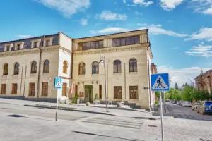
(2016 estimate) Artik Shirak 1939 9 19,534 18,800 Gyumri Shirak 5th century BC as Kumayri
rebuilt in 1837 as Alexandropol 54 121,976
117,700
Maralik Shirak 5th century (first mentioned) 4 5,398 5,500Rural communities
- Aghin
- Aghvorik
- Akhurik
- Akhuryan
- Alvar
- Amasia
- Aniavan
- Anipemza
- Anushavan
- Arevshat
- Arevik
- Arapi
- Ardenis
- Aregnadem
- Arpeni
- Ashotsk
- Aygebats
- Azatan
- Bandivan
- Basen
- Bashgyugh
- Bavra
- Bayandur
- Beniamin
- Berdashen
- Byurakn
- Dzithankov
- Dzorakap
- Dzorashen
- Garnarich
- Geghanist
- Getk
- Getap
- Gharibjanyan
- Ghazanchi
- Goghovit
- Gtashen
- Gusanagyugh
- Harich
- Hartashen
- Hatsik
- Haykadzor
- Haykasar
- Haykavan
- Hayrenyats
- Hoghmik
- Horom
- Hovit
- Hovtashen
- Hovtun
- Hovuni
- Isahakyan
- Jajur
- Jajuravan
- Jradzor
- Jrapi
- Jrarat
- Kakavasar
- Kamo
- Kaps
- Karaberd
- Karmrakar
- Karmravan
- Karnut
- Keti
- Krasar
- Krashen
- Lanjik
- Lernagyugh
- Lernakert
- Lernut
- Lusaghbyur
- Lusakert
- Marmashen
- Mayisyan
- Meghrashat
- Meghrashen
- Mets Mantash
- Mets Sariar
- Mets Sepasar
- Musayelyan
- Nahapetavan
- Nor Kyank
- Norshen
- Panik
- Pemzashen
- Pokr Mantash
- Pokr Sariar
- Pokr Sepasar
- Pokrashen
- Salut
- Saragyugh
- Sarakap
- Saralanj
- Sarapat
- Saratak
- Sarnaghbyur
- Shaghik
- Shirak
- Shirakavan
- Sizavet
- Spandaryan
- Tavshut
- Torosgyugh
- Tsaghkut
- Tsoghamarg
- Tufashen
- Vahramaberd
- Vardaghbyur
- Vardakar
- Voghji
- Voskehask
- Yerazgavors
- Zarishat
- Zorakert
- Zuygaghbyur
- Aghin kayaran, belongs to the Aghin community.
- Bardzrashen, belongs to the Isahakyan community.
- Darik, belongs to the Zorakert community.
- Hatsikavan, belongs to the Hatsik community.
- Kamkhut, belongs to the Gtashen community.
- Kharkov, belongs to the Norshen community.
- Paghakn, belongs to the Berdashen community.
- Yeghnajur, belongs to the Garnarich community.
- Akhuryan kayaran, belongs to the Gharibjanyan community.
- Aravet, belongs to the Alvar community.
- Lorasar, belongs to the Tsaghkut community.
- Yerizak, belongs to the Zarishat community.